Some of the oldest maps known to man are from ancient Mesopotamia and Egypt. These maps are thousands of years old. Greek cartographers like Anaximander and Hecataeus created early maps using geographic and astronomical knowledge of their time.
More accurate maps were created after the rediscovery of Ptolemy’s work in the 1500s. Nautical charts and portolan maps helped European exploration. The Mercator projection became the standard world map for centuries. National surveys in the 1700-1800s produced detailed topographic maps. The 1900s introduced digital cartography with GIS and online maps.
Maps have a long history of evolution. Here are the 6 oldest maps of Europe ever discovered.
Oldest Map of Europe
6. Ebstorf Map
Year Created: 1234-1240 AD
Discovered: 1843
Still Exists?: No, the original was destroyed in 1943.
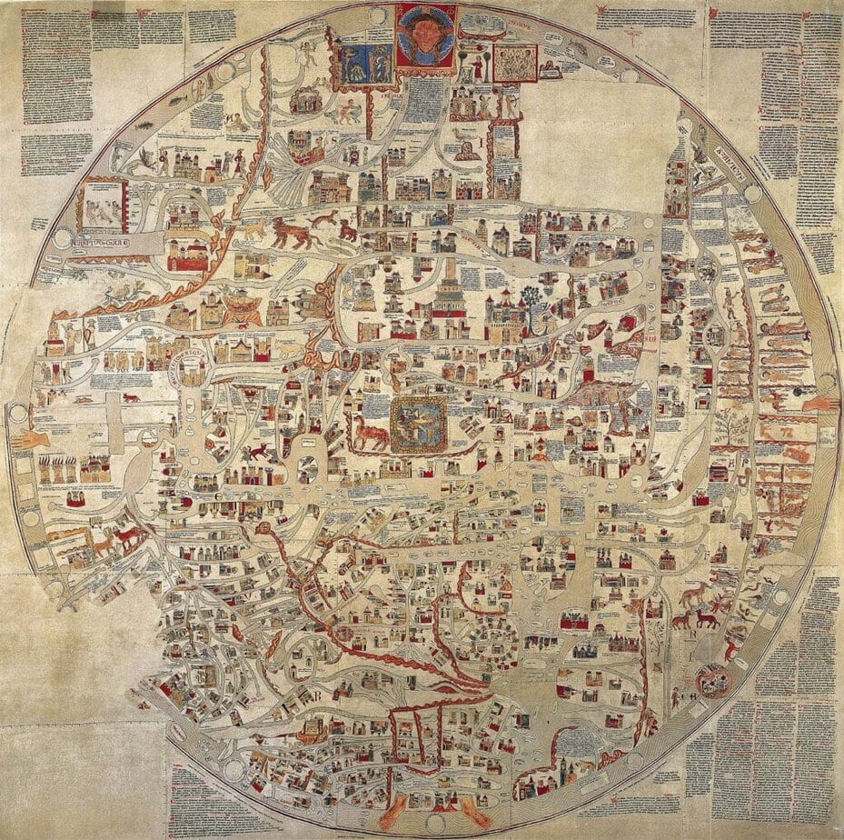 Photo Source: Wikimedia Commons
The Ebstorf map was a huge medieval mappa mundi or world map. It is believed to have been created between 1234 and 1240 AD. The Ebstorf map was made by Gervase of Ebstorf. The map was found in 1843 in northern Germany. It was discovered in a convent in Ebstorf.
The Ebstorf map had the head of Christ at the top, with his hands on either side and his feet at the bottom. The map also had texts in it that described animals, the world’s creation, and how the world was divided into three parts.
The original Ebstorf Map was massive. It measured around 12 feet by 12 feet and was painted on 30 goatskins. However, it was destroyed during the Allied bombing of Hanover in World War II.
Today, only photographs and color facsimiles of the Ebstorf Map remain.
Did You Know?
The Ebstorf map is a much more elaborate version of the common medieval T-O map. It has Jerusalem at the center and the East at the top. The map focused on the medieval worldview and included both pagan and biblical history.
5. Waldseemüller Map
Year Created: 1507
Discovered: The original was rediscovered in 1901
Still Exists?: Yes, the original is housed at the Library of Congress
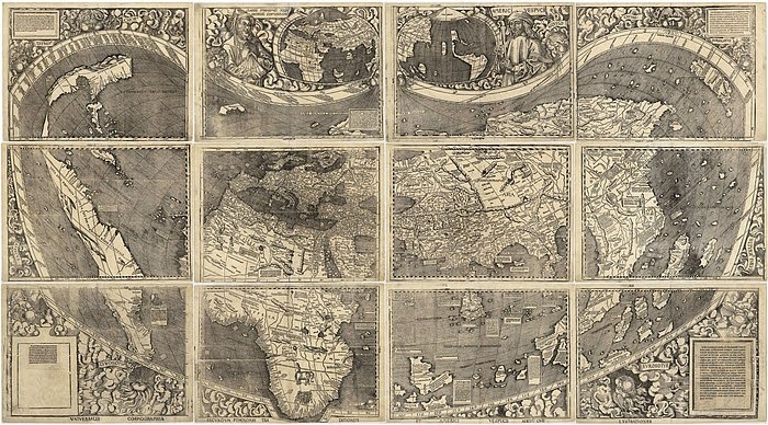 Photo Source: Wikimedia Commons
The Waldseemüller Map was created by the German cartographer Martin Waldseemüller in 1507. It is the first map to use the name “America” for the newly discovered lands in the West. The Waldseemüller Map is a printed wall map.
The Waldseemüller Map separated the American continents from Asia with an ocean in between. It is based on a modified version of Ptolemy’s map projection. The Waldseemüller Map included information from explorers like Amerigo Vespucci and Christopher Columbus.
The Waldseemüller Map also had an inscription connecting Vespucci as the “discoverer” of the new lands. It also challenged the view that the Americas were part of Asia. Only one complete original copy of the wall map is known to exist today. The map’s globe gores also contained the name “America.”
Did You Know?
The Waldseemüller Map has a miniature inset showing the American continents connected by an isthmus. This shows Waldseemüller’s uncertainty about the geography of the New World.
4. Beatus Maps
Year Created: 8th century AD
Discovered: The original manuscript is lost, but several copies have survived
Still Exists?: Yes, copies of the Beatus Maps still exist
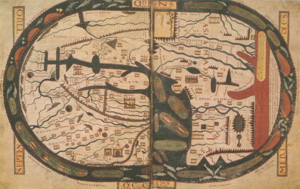 Photo Source: Wikimedia Commons
The Beatus Maps are a series of medieval world maps (mappa mundi). It was created to show the work of the Spanish monk Beatus of Liébana. Beatus based the maps on accounts from Isidore of Seville, Ptolemy, and the Hebrew Bible.
The map shows the world as a circular disc surrounded by the ocean, with Asian, African, and European continents. The map has Jerusalem at the center based on medieval Christian theology. The maps illustrate the first dispersal of the Apostles instead of any precise geographical representations.
The maps divide the continents among the descendants of Noah’s three sons – Shem, Ham, and Japheth. It also has the Garden of Eden in the east and the wonders of Asia, like the Mountains of Gold. While the original Beatus manuscript is lost, many copies of the maps still exist.
Did You Know?
The Beatus Maps show the medieval European view of the earth as a flat plane covered by the heavenly vault.
3. Ravenna Cosmography
Year Created: 700 AD
Discovered: Existing 3 manuscript copies dated to 13th-14th centuries, first published in 1688
Still Exists?: Yes, in three medieval manuscript copies
 Photo Source: Wikimedia Commons
The Ravenna Cosmography was created around 700 AD by an anonymous cleric in Ravenna, Italy. It lists place names from India to Ireland. The text shows that the author often used maps as sources for the Cosmography.
Three manuscript copies of the Cosmography are known to exist. They are from the 13th and 14th centuries. The Vatican Library has a 14th-century copy; a 13th-century copy is in Paris at the Bibliothèque Nationale; another 14th-century copy is in the library at Basle University.
The text presents place names in a confusing way. It has a lot of abbreviations and a lack of punctuation.
Scholars have extensively studied the section on Roman Britain. First, they tried to identify the ancient places based on their similarity to modern names. Later, archaeological evidence helped confirm the Cosmography’s information.
Did You Know?
The Ravenna Cosmography was first published in 1688 by Porcheron, using the Vatican manuscript as the source.
2. Tabula Peutingeriana
Year Created: 4th-5th century AD
Discovered: 1494, Worms city, Germany
Still Exists?: Yes
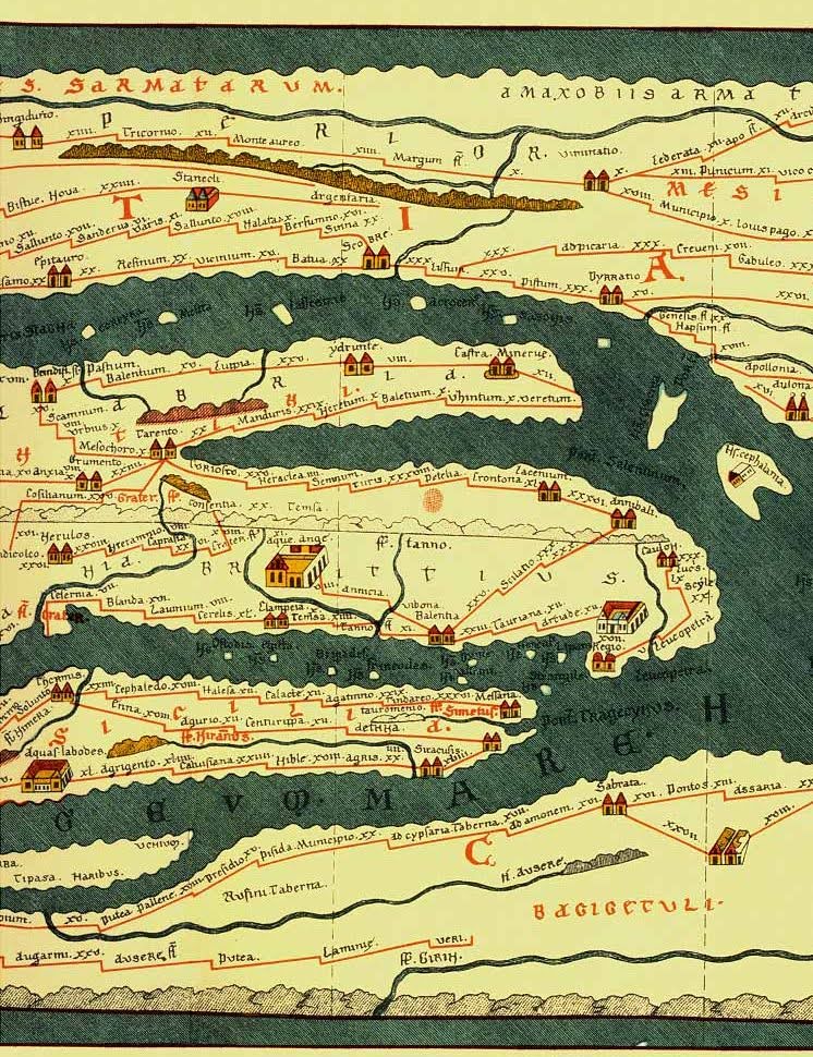 Photo Source: Wikimedia Commons
The Tabula Peutingeriana is an ancient Roman road map. It portrays the empire’s large network of routes. It is believed to be based on a map created by Roman general and architect Marcus Vipsanius Agrippa in the 1st century BC.
The Tabula Peutingeriana was discovered in 1494 by the German scholar Conrad Celtes in a library in the city of Worms. The map is named after Konrad Peutinger. He received the map after Conrad Celtes’ death and temporarily owned it in the early 16th century.
The Tabula Peutingeriana includes an elongated scroll that covers Europe, North Africa, and parts of Asia. It is not accurate or geographic style like the modern maps. The Tabula Peutingeriana depicts cities, roads, distances, and other features in a schematic style. The map shows the 4th or 5th century, including the city of Constantinople.
The map was partially reconstructed in 1898 to include the missing Iberian Peninsula and Britain. The original Tabula Peutingeriana is at the Austrian National Library and is rarely displayed due to its fragile condition.
Did You Know?
The Tabula Peutingeriana is considered the only surviving map of the Roman Empire’s road system.
1. The Saint-Bélec Slab
Year Created: c. 1875 BC
Discovered: 1900 in Finistère, Brittany, France
Still Exists?: Partially – the upper portion is missing
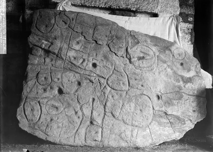 Photo Source: Wikimedia Commons
The Saint-Bélec Slab was discovered in 1900 from a prehistoric burial site in Brittany, France. It is made of grey-blue schist with a length of 7 feet and a width of 5 feet. The Saint-Bélec Slab is from the early Bronze Age around 1875 BC. It is considered the oldest map of Europe and possibly the earliest map of any territory.
The slab has engravings of geometric shapes like lines, circles, and squares. These symbols match the landscape of the Odet Valley region in Brittany.
There is a central circular motif that could represent the prince’s burial site or residence. The upper portion of the slab is missing. It is believed that the slab was broken and reused as building material in the burial crypt. The fragments of the missing upper portion are still being searched for today.
Did You Know?
Researchers believe the Saint-Bélec Slab map may have represented a Bronze Age principality.
Conclusion
Maps have evolved a lot over the centuries. From abstract knowledge of the earth’s geography to tools that can give us exact coordinates. From maps on a stone to GPS, we simplified life.
The ancient Romans advanced cartography. They made detailed road maps like the Tabula Peutingeriana to document their empire. In Medieval Europe, “Mappae Mundi” focused on Christianity, with Jerusalem at the center.
It became more accurate and realistic over the years. These 6 oldest maps of Europe are no longer accurate. But they were a start in the developments. So, here to coming a long way from from believing that the Americas and the Asian continent were same.